Coalstoun
Copper and Gold Project
Asset Summary
EPM 14079 (Coalstoun Copper and Gold Project – 176.5 km2) in the New England Orogen is located in southeast Queensland between the towns of Gayndah and Goomeri, 215 km due northwest of Brisbane. ActivEX Limited holds 100% interest in tenement EPM 14079 a recent acquisition from Newcrest Limited.
The Coalstoun Copper and Gold Project is situated at the intersection of the NNW trending Perry Fault zone (host to Mt Rawdon +2Moz gold deposit) and NE trending (Darling Lineament related) structures.
Project Highlights
– Recent acquisition of Coalstoun EPM from Newcrest Mining Limited (176.5 km2).
– Established target at the Coalstoun deposit with Mineral Resource (JORC Code and Guidelines (2012)).
– Coalstoun copper deposit total Inferred Mineral Resource of 26.9Mt @ 0.38% Cu (for 102,700t Cu contained); including a supergene copper Inferred Mineral Resource of 7.0Mt @ 0.47% Cu(for 32,700t Cu contained) in the partially oxidised zone (ASX 31 March 2015).
– Contiguous tenement package with ActivEX Limited Esk Copper and Gold Project (327.8 km2 – Figure 2).
– Contiguous tenement package with ActivEX Limited Barambah Gold Project (108.2 km2 – Figure 2).
– Shallow, high grade supergene copper with further potential to upgrade and extend.
– Significant potential for low grade, high tonnage copper.
– Associated gold and copper breccia systems and epithermal gold systems.
– Potential for high grade, skarn related copper.
Project Details
The Coalstoun Copper and Gold project is host to mineralisation with similarities to many High-K Calc-alkalic to Alkalic Porphyry copper-gold deposits,
Significant drilling intersections from the Coalstoun porphyry include:
- 453.4m at 0.24% copper from 203.9m to EOH (CDD003)
- 199.1m at 0.36% copper from 17.1 to EOH (ESSO12)
- 390.7m at 0.30% copper from 0m to EOH (ESSO22)
- 407.8m at 0.27% copper from 36.6m to EOH (ESSO32)
Exploration targeting concepts include:
- Shallow epithermal gold potential associated with the SE Breccias in Coalstoun EPM;
- Potential to significantly extend and upgrade shallow high grade supergene copper mineralisation at the Coalstoun prospect;
- Potential to discover copper mineralisation at depth below the Coalstoun supergene copper and for analogous Coalstoun/Cadia style mineralisation;
- Deep porphyry and proximal high-grade gold breccia potential (Mt Rawdon style) of the SE Breccias; and
- Porphyry gold/copper potential of the Staib’s Hill rhyolite/dome.
The Coalstoun Copper and Gold project
The area is currently used for cattle grazing and peanuts are grown on the red soil basalt plains. The majority of the Coalstoun Copper and Gold project area consists of cleared plains with timbered hills to the east and west with some areas of thick lantana and vine scrub. Access to all areas is good, with the Burnett Highway and Isis Highway running through the centre of the EPM. Numerous secondary roads and farm tracks also provide good access. Previous exploration of the steeper areas has left a network of accessible four-wheel drive tracks.
The CoalstounCopper and Gold project is situated on the Maryborough 1:250,000 sheet (SG5606) as well as the Gayndah (9246) and Biggenden (9346) 1:100,000 sheets.
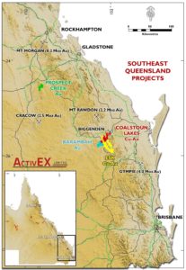
Figure 1: Coalstoun Copper and Gold Location
The project comprises one, 100% ActivEX Limited held tenement (EPM 14079 – Figure 2) with a combined area of 176.5 km2.

Table 1: Tenement Details
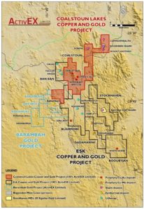
Figure 2: Coalstoun Copper and Gold Project Tenements showing
Historical Exploration Highlights
There have been several phases of modern exploration in the Coalstoun Copper and Gold project area. Historical exploration highlights presented below:
Coalstoun (EPM 14079)
1968: Coalstoun Porphyry system discovered by Kennecott Exploration Pty Ltd.
- 1974: Esso Australia Ltd estimated a “resource” at the Coalstoun Porphyry of 85Mt at 0.29% copper above 300m depth including a shallow secondary copper enriched zone of 7.7Mt at 0.66% copper (non-JORC compliant).
- 1985: Gold mineralisation discovered by Poseidon Ltd at Staibs Hill prospect highlighting potential for further gold mineralisation in the Peripheral Volcanics east of the Coalstoun Porphyry copper deposit.
- 1985 – 1986: A number of companies tested for gold in the Peripheral Volcanics with drill assays up to 2 m at 8.4 g/t Au from Staibs Hill
- 2003 – 2013: Drilling by Newcrest Mining Limited reviled low grade copper mineralisation at the Coalstoun porphyry associated with potassic alteration and high magnetic response, significant copper and gold mineralization in the SE Breccias and gold bearing high sulphide quartz loads and veins <1m wide in the Peripheral Volcanics around associated with Staibs Hill.
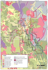
Figure 3: Coalstoun Copper and Gold project geology
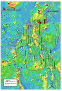
Figure 4: Coalstoun Copper and Gold Project regional airborne magnetics
Coalstoun – EPM 14079 (Newcrest Acquisition)
Tenement Summary
The Coalstoun EPM consists of a number of breccia-pipe hosted Au-Cu prospects surrounding substantial Cu-Au porphyry intrusive bodies. In the northeastern reaches of the tenement, significant skarn mineralisation exists along extensions of the Biggenden Skarn, as well as potential skarn mineralisation at Robina.
Coalstoun Poryphyry
The Coalstoun Porphyry System was the dominant focus of exploration by Newcrest, and occurs as a Middle Triassic Cu-Au-Mo mineralised porphyry system emplaced in the Goodnight Block during regional shortening across the Northern New England Orogen in southeast Queensland. Porphyry copper mineralisation is associated with a topographic low surrounded by the steep hills of the Walla Range.
Hydrothermal alteration and mineralisation is characterised by multiple porphyritic intrusions and associated igneous-matrix breccia. Newcrest interpreted a 50° plunging intrusive system to the southwest based on the zonal arrangement of hydrothermal alteration.
Up to four main plagioclase-biotite-phyric monzonites occur within the Coalstoun prospect. Geochemistry reveals that the intrusive rocks associated with hydrothermal alteration and mineralisation are alkalic (K2O + Na2O > 6 wt. %). Geochemistry of the Coalstoun intrusive rocks, combined with the observed hydrothermal alteration, implies that the historical exploration model applied to this district may be incorrect. Exploration analogues include Northparkes E26 and the equivalent deposits of the Cadia district. Importantly, these systems are zoned with respect to Cu and Au, with the Cu-only portions of the system found towards the top of the system.
New U-Pb dating of the Coalstoun intrusive complex show mean ages of 234 ± 3.1 Ma and 232 ± 2.3 Ma consistent with the Re-Os age for mineralisation (molybdenite-bearing quartz vein; 231.5 ± 0.9 Ma). Thus Coalstoun is considered to be time equivalent to the lithologically-controlled Mt Rawdon deposit containing +2Moz Au.
The magnetic data shows a number of interesting features. The phyllic zone is mapped-out on the western side by a more subdued magnetic response within a magnetic high. The intrusives stand out as magnetic highs. A prominent NNE striking feature (Darling Lineament orientation) appears to control and may truncate mineralisation to the northwest.
At Coalstoun, hydrothermal alteration is zoned from a potassic core (K-feldspar-biotite- magnetite-albite) hosting Cu, Mo and Au that is rimmed and cut by late stage phyllic veins and fault-controlled quartz-sericite-pyrite alteration. The feldspathic alteration in the deposit is distinctly hematite dusted, consistent with the oxidized alkali-rich nature of the associated magmatism. Propylitic (chlorite-epidote) extends regionally.
Cross-cutting the Cu mineralisation and extending regionally into the propylitically altered wall-rock are multi-stage hydrothermal-cemented breccias (including anhydrite-pyrite-calcite, pyrite-specular hematite-albite-ankerite-hematite, chlorite-pyrite-albite-calcite, and quartz-pyrite-calcite-(manganese)-hematite assemblages). The anhydrite-bearing hydrothermal facies is known to host high Cu (up to 1 wt. %), whereas the specular-hematite-bearing facies found ~2.5 km from Coalstoun hosts up to 0.5 g/t Au and 1 wt. % Cu.
Metal-bearing porphyry-related hydrothermal alteration, veins and breccias remain an attractive exploration target. The shallow, largely vertical drilling of the moderately dipping intrusive complex, and the recognition that the porphyry Cu-Au-Mo mineralisation and associated zoned alteration are tilted, suggests the mineralised system has not been adequately drill tested and remains open in all directions. Further potential exists for a higher grade gold core to the system, which has not yet been realised from drilling to date.
Drill hole CDD016 provides further evidence that the system plunges to the SW, with several porphyries interpreted to extend to the upper hole CDD003. Anomalous gold was also intersected with grades of 17m @ 0.3g/t Au, 3.16g/t Ag and 0.08% Cu from 500m and 18m @ 0.19g/t Au, 6.5g/t Ag and 0.14% Cu from 524m.
Best results from drilling within the Coalstoun Porphyry system are summarised in Table 2.
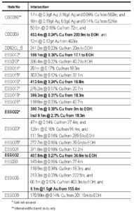
Table 2: Summary Assay Intersections from Historic Drilling within the Coalstoun Porphyry System
Significant assay Intersections are calculated using ≥0.1g/t Au, ≥0.1% Cu with a maximum of 4 sample interval internal dilution; all intervals to 2 sig. figures.
Esso Australia, estimated a non-JORC compliant ‘resource’ of 85Mt @ 0.29% Cu. The deposit was re-evaluated by Newcrest following additional drilling, with a revised Exploration Target between 70 – 150 Mt at 0.15 – 0.35% Cu. Their potential quantity and grade of the Exploration Target was conceptual in nature, and there was insufficient exploration and resource evaluation to estimate a Mineral Resource as per their standards, and it is uncertain that further exploration will result in the estimation of a Mineral Resource.
Southeast Breccias
At the SE Breccia prospect, three related exploration targets exist. The focus to date has been the Au-Cu potential of the Permo-Carboniferous breccia pipe (Mt Rawdon style). There also exists the potential for the porphyry source of the mineralising hydrothermal fluids, as well as shallow epithermal potential.
Drilling to date at the SE Breccia prospect has intersected encouraging low grade Au anomalism (e.g. 23m @ 0.81g/t Au from 423m from CDD008) within clast supported hydrothermal breccias. A total of 5 deep core holes have now been drilled into the prospect. Open-space colloform textures have been noted in the breccia matrix in a few of the holes, but it is unknown whether this represents part of an epithermal system. The breccias were intersected over 350m below surface, leaving ample room for a shallow high-grade deposit.
Alteration at the SE Breccias is dominated by anhydrite±magnetite±chlorite±epidote±pyrite which elsewhere can be typical of the inner propylitic zone of a porphyry deposit. Albite is also present and is indicative of sodic-calcic alteration. In addition to the shallow epithermal target, a porphyry target may also exist below this zone. Alteration would suggest the porphyry may be 500 – 700m down dip. There is some evidence of pyrite-sericite veins (peripheral to a porphyry target) and sugary quartz-sulfide veins noted in CDD006.
The lithologically controlled albite-actinolite alteration is similar to Mt Rawdon, with current intercepts being lower grade. Typical grades at Mt Rawdon are an order of magnitude greater. Significant potential also exists in the recognition of the Mt Rawdon-style Au-bearing lithologically controlled albite-actinolite alteration occurring in the Southeast Breccia zone. This has not been assessed in detail.
The system has not been tested for a similar SW plunge as the interpreted plunge on the Coalstoun Porphyry. It is likely that if the Coalstoun porphyry is plunging, the entire block is plunging.
Staibs Hill
Mineralisation at Staib’s Hill is thought to be associated with a rhyolite plug/dome. To date, 13 holes have been drilled into the immediate prospect, most of which are shallow. The deepest hole is CDD007 (650.5m).
Drill hole CDD007 intercepted carbonate-sulfide±quartz stockwork veining. This is typical of a “Carbonate Base-Metal” style (e.g. Lake Cowal) mineralisation, possibly as part of the upper zone of a porphyry system. The Staib’s Hill “rhyolite” may be highly altered quartz-feldspar porphyry. To date, exploration at Staib’s hill has assumed the intrusion is still vertical, however if the west dipping model at Coalstoun is applied, then hole CDD007 has failed to test the down-dip potential of the shallow gold anomalism intersected in the historic drilling. Mineralisation is open down-dip towards the west.
Seven Sisters
Mining by R. Murdoch in the late 1980’s, exploited the weathered portion of the Seven Sisters lode via a series of four shallow open cuts and slots. Approximately 30,000 tonnes at 5 g/t Au were mined and treated. The main lode strikes approximately north south and has a 40 to 60 degree westerly dip. The 1 to 3m wide lode is structurally controlled and strong shearing and slickensides can be seen in some of the ore boulders left behind. The lode has a total strike length of 500m however it is probably cut by several small faults. It is hosted in silicified and sericite altered meta-sediments.
In his report for Ban Ban Mining (CR22309 page 14) Murdoch includes a brief description of the lode as quartz, limonite fault breccia with best grade where the lode is cut by a porphyry intrusion. The fault breccia is very different to the breccia bodies, which form the ridge tops and peaks of the Walla Range to the east.
The porphyry body cutting the gold lode at station 44 is texturally and compositionally similar to the intrusions hosting the porphyry copper mineralisation and provides evidence that the gold mineralisation is of similar or younger age to the copper mineralisation.
Robina
The Robina prospect consists of a large magnetic signature, similar to that of the Biggenden Skarn to the east, bordering the Degilbo Granodiorite responsible for mineralisation at the Biggenden Skarn. To date, no significant exploration has been completed over the prospect.
Mineral Resources
Maiden Inferred Mineral Resource estimates (2012 JORC Code & Guidelines) have been completed at the Coalstoun copper deposit located within the Coalstoun Copper and Gold Project. Total Inferred Mineral Resource of 26.9Mt @ 0.38g/t Cu for 102,700t Cu contained; including a supergene copper Inferred Mineral Resource of 7.0Mt @ 0.47% Cu (for 32,700t Cu contained) at 0.3% Cu cut-off (Figure 3).
ActivEX acquired the Coalstoun tenement (EPM 14079) from Newcrest in November 2013 with formal transfer completed in late July 2014 (Figure 2). Resource estimates have been completed within approximately eight months of tenement transfer and have exclusively used historical information.
The deposit is located within the Coalstoun tenement (Figure 2) and is situated about 25km east of Gayndah in southeast Queensland.
EPM 14079 sits within the Esk Basin (formerly Esk Trough), a tectonostratigraphic member of the Devonian to Triassic New England Orogen.
The Coalstoun Intrusive Complex occurs as a Middle Triassic Cu-Au-Mo mineralised porphyry system emplaced in meta-argillites of the Goodnight Block during regional shortening across the Northern New England Orogen in southeast Queensland (Figure 5). The Coalstoun copper deposit is associated with a topographic low surrounded by hills of the Walla Range, in the middle of the complex.
Hydrothermal alteration and mineralisation is characterised by multiple porphyritic intrusions and associated igneous-matrix breccias.
At least three intrusives are known from the drill hole information. Two are syn-mineral, porphyritic intrusions and one is a smaller post-mineral porphyritic intrusion. The syn-mineral intrusives vary in xenolith percentage to form ‘igneous breccia’ which are common throughout the area. Two hydrothermal breccia phases have also been identified grading from quartz-pyrite dominant to anhydrite, although the anhydrite phase appears to post-date mineralisation.
The Company commissioned independent consulting geologists H&S Consultants Pty Ltd (“H&SC”) of Brisbane, Australia to complete a resource estimate for the Coalstoun copper deposit.
The resource estimates are based on a total of 48 drill holes (9 reverse circulation, 1 combined RC/diamond and 38 diamond drill holes, Table 2 in Appendix II) for a total of 12,701.6m with 5,316 copper assay samples mainly varying in sample length between approximately 0.5 and 6 metres. Wireframes were interpreted at a nominal Cu cut off of 0.1% for the primary mineralised intrusive and the oxide mineralisation with oxidation surfaces also generated (Figure 6). The surface dimensions of the mineralisation at a 0.3% Cu cut off are approximately 1.1km by 0.5km, extending to 0.5km in depth.
Copper mineralisation consists of both disseminations and veinlets of chalcopyrite, chalcocite or copper oxides depending on the depth of oxidation from weathering processes. Samples from surface appear to be depleted of copper mineralisation when compared to deeper samples. Below this oxidized zone is a secondary sulphide supergene/partially oxidized zone ranging from 0.5m to approximately 36m thick that lies at a depth of about 15-35m below surface (Figure 7). This supergene-partially oxidized zone lies on top of the primary mineralised intrusive.
The oxide copper was modelled horizontally whereas the primary copper was modelled using an ellipsoidal set of parameters.
A total of 3,435 three metre composites were extracted from the drill hole database using the main mineralised intrusion wireframe; No top cutting was applied to the data.
Reporting of the resource estimate used a 0.3% copper cut off on un-cut data with a partial percent volume adjustment for the mineralised intrusion wireframe. Default density values were used as no density data could be obtained from historic reports.
All resources are classified as Inferred based on the wide and irregular drill hole spacing, limited QAQC data and lack of density data (Figure 6 and Figure 7).
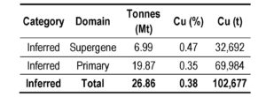
Table 2: Summary Assay Intersections from Historic Drilling within the Coalstoun Porphyry System

Figure 5: Coalstoun Intrusive Complex geology
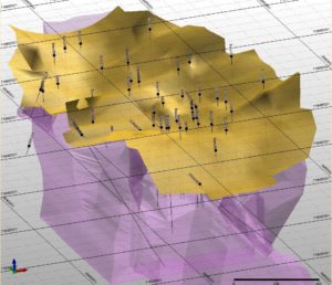
Figure 6. Isometric northeast view of drill holes and mineral zones (magenta = mineralised intrusion and country rock, yellow = supergene Cu and upper-oxidised [combined for clarity])
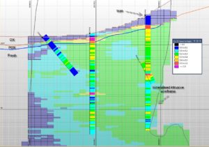
Figure 7. Copper block grade distribution – cross section 7163475N
The Coalstoun Copper and Gold Project is located in the New England Orogen, 75km west of Maryborough in southeast Queensland.
ActivEX has an established target at the Coalstoun deposit with Mineral Resource (JORC Code and Guidelines (2012)). Coalstoun copper deposit total Inferred Mineral Resource of 26.9Mt @ 0.38% Cu (for 102,700t Cu contained); including a supergene copper Inferred Mineral Resource of 7.0Mt @ 0.47% Cu (for 32,700t Cu contained) in the partially oxidised zone (ASX 31 March 2015, Appendix II).
Potential exists to extend and upgrade shallow high grade supergene copper mineralisation at the Coalstoun copper deposit, discover copper mineralisation at depth below the supergene copper zone and also for analogous Cadia style mineralisation.
Evidence for associated Cu-Au breccia systems and epithermal Au systems on the margins of the Coalstoun porphyry complex provide further exploration potential.
The Coalstoun Copper and Gold Project is a large tenement package prospective for copper and gold mineralisation and contiguous with ActivEX Limited Esk Copper and Gold and Barambah Gold Projects.
Appendix I
Detailed Summary of Exploration History
Coalstoun (EPM 14079)
1964 – 1965 Queensland Department of Mines: drill tested the Seven Sisters gold mine.
1967 – 1970 Kennecott Exploration Pty Ltd: discovered Coalstoun porphyry copper systems (drilled 13 diamond holes).
1971 Mines Administration Pty Ltd: completed 7 RC holes testing for secondary copper enrichment in the porphyry system.
1972 – 1975 Esso Australia Ltd (Esso): drilled 42 vertical diamond holes and outlined a non JORC compliant ‘resource’ of 85Mt at 0.29% copper above 300m depth including a shallow secondary copper enriched zone of 7.7Mt at 0.66% copper.
1983 Samantha Exploration NL, BHP and Newmont: evaluated the gold potential for the area. They re-sampled some Esso and Kennecott holes for gold. Newmont conducted rock-chip sampling with no success.
1985 Poseidon Ltd: delineated 20 rock-chip anomalies in the Peripheral Volcanics. They drilled 3 diamond holes into Staib’s Hill. The best gold intercept was 61.2m at 0.35g/t gold from 14m (SHD1).
1987 – 1990 Burmine Ltd in joint venture with Renison and Ban Ban Mining: Conducted IP and EM surveys to delineate drill targets. Drilled 3 holes near Staib’s and Marshall’s Hill. Burmine also completed 16 shallow RC holes at Marshall’s Hill in which 12 holes intersected broad low grade gold mineralisation. The best intersection was 16m at 0.4g/t gold. Ban Ban Mining explored the western margin of the Walla Range drilling 6 RC holes around the 7 Sisters gold Mine.
1991 – 1993 CRAE: explored the area using surface geochemical sampling, airborne magnetics, ground magnetics and geological mapping. Five drill-holes were completed in the western central area of the Walla Range. One of these holes was a 261.2m deep angled hole into the Esso Resource which returned assays up to 2m 0.7% copper in the supergene enriched zone.
1993 – 1994 Golden Breed: Conducted ground magnetics and drilled 12 RC holes. The best intercept was 80m at 0.38g/t gold from 0m (SHRC2) near Staib’s Hill.
1995 – 1996 MIM Exploration Pty Ltd in joint venture with Golden Breed: undertook a program of mapping, geochemical sampling and ground magnetics. 6 RC drill-holes were completed with the best results of 2m at 9g/t gold near Staib’s Hill.
1999 – 2000 Metallica Minerals/Coolgardie: drilled 5 shallow RC holes testing scattered targets on the margins of the porphyry system near Staib’s Hill and the western side of the 7 Sisters Complex with disappointing results
2003 – 2013 Newcrest Mining Limited: conducted extensive soil, stream and rock chip sampling including ridge and spur sampling, an IP survey RC and diamond drilling. Results reviled low grade copper intercepts from the Coalstoun porphyry associated with potassic alteration and high magnetic response, Significant copper and gold mineralization in the SE Breccias and gold bearing high sulphide quartz loads and veins <1m wide in the Eastern volcanics.
